
Baldernock
Baldernock is a hamlet bounded by the Campsie Fells to the north and east, the River Kelvin to the south and the Pow Burn to the west.
The heart of the village is its parish church. The most notable residents were Magnus Magnusson, well-known broadcaster and translator of Icelandic sagas and architect Geoffrey Jarvis among whose many projects was the superlative restoration of Chatelereault, once the hunting lodge of successive Dukes of Hamilton.
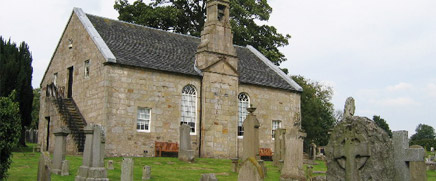
In the 13th century, Baldernock was known as Bathernock and in the 18th century as Badernock. As with most hamlets and villages, community life centred on its church. Baldernock Parish Church dates from 1795 although there was an earlier church of indeterminate age. The oldest gravestone in the kirk cemetery dates from 1644.
Bardowie
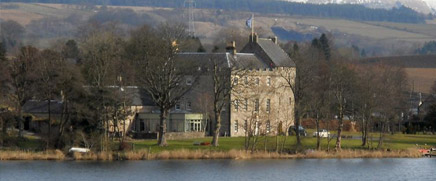
Bardowie is a small village located some two miles south east of Milngavie and 6 miles north of Glasgow. Dominating the skyline is the impressive Bardowie Castle which was built in 1566 and overlooks Bardowie Loch which hosts a small yachting club. It has been much restored in recent years and is now a private residence. The castle was originally rectangular in plan but additions were made during the 17th and 18th centuries.
The Bardowie Estate was originally owned by the Galbraith family who were granted the lands of Buthernock (which included Bardowie) by Maldoven and Malcolm, Earls of Lennox, in the 13th century. It became the property of the Hamiltons of Cadzow (through marriage) in the early 14th century and thereafter, by the Buchanans of Spittal. In 1707, the sister of John Hamilton of Bardowie married Gregor “Black Knee” MacGregor, chieftain of the proscribed clan at that time and Rob Roy’s nephew.
Huntershill
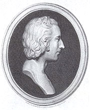 Huntershill village is located at the top of Crowhill Road in Bishopbriggs and will be identified forever with Thomas Muir (left), the Father of Scottish Democracy. He was born in 1765, the son of a wealthy banker and, in adult life, became a lawyer, having studied and practiced law in Glasgow and Edinburgh. A champion of political reform, he sympathised with the revolutionary cause in France which led to his arrest on 4th August 1793 on the grounds of creating ‘disaffection by means of libel and seditious speeches’ for which he received a sentence of 14 years in the penal colony at Botany Bay. Three years later, he escaped eventually ending up in France where he was regarded as a revolutionary hero. Muir died on 26 January 1799 aged 33 years. A cairn dedicated to his memory was unveiled at Huntershill in 1997.
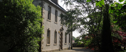
Huntershill House (above), an 18th-century building in Bishopbriggs, became the Muir family home from the early 1780s. Now owned by East Dunbartonshire Council, it is a Category B Listed building as well as being on the Buildings at Risk Register.
Lenzie
The early history of Lenzie is shrouded in mystery. Records indicate that much of the land in the area was owned by the Comyn family whose castle was built on the site of the Antonine Wall’s fort at Kirkintilloch. It is believed that the area was known at the time variously as Lengze, Lenneth or Lingie. Much later, a church (St Ninian’s) was built at Oxgang which was replaced in 1644 by a new parish church in Kirkintilloch. It stands to this day but is now known as the Auld Kirk Museum.
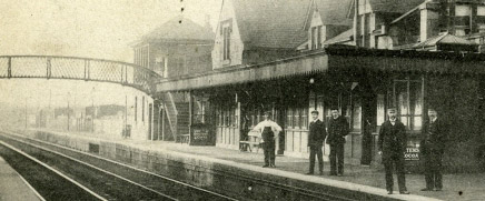
Lenzie itself began to develop with the opening of the Glasgow to Edinburgh Railway. A station was built at Garngaber close to Kirkintilloch. Given its proximity to Glasgow, commuters began erecting homes in the area to which the responded by issuing free season tickets to those using Garngaber. When piped water became available in the 1870s, it resulted in a housing boom in Lenzie still seen today as a much sought after area in which to live.
Strathblane & Blanefield
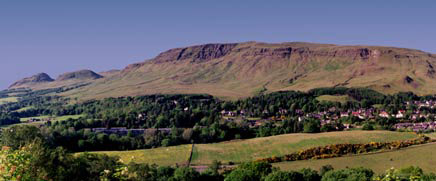
Strathblane and Blanefield nestle beneath the Campsie fells (left). Strathblane was the name given to the parish comprising Edenkill, Netherton and Mugdock dating back some considerable time. Its neighbour, Blanefield, is of more recent origin having been founded in the 19th century when the Blanefield Calico Works established production, at one point employing over 500 workers. Its closure in 1898 brought misery to a community which had come to rely upon it for employment. The site was finally levelled in 1910.
During the 1860s, the Blane Valley Railway improved communications between what was regarded as a comparative backwater with the industrialised central belt. The line remained opened as a passenger line until 1951 and as a freight line until 1959. In 1867, a Free Kirk was built followed by a Roman Catholic Church in 1893. The creation of the latter was due to the influx of Irish navvies working on a second water tunnel which formed part of the Loch Katrine scheme to provide clean water for the citizens of Glasgow. Today, this achievement remains a monument to Victorian engineering.
In the aftermath of the Clydebank Blitz in March 1941, German bombers flew over Strathblane and Blanefield (above) and jettisoned the remainder of its bomb load resulting in the deaths of four local residents.
Twechar
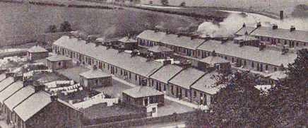
Twechar was once a close-knit mining community (left) which began to expand in the 1860s when William Baird & Company sank pits there and at Gartshore. What started off as a row of miners cottages built at this time on the south bank of the Forth & Clyde Canal had expanded to 160 dwellings by 1900. Conditions were primitive, there being no sanitation, only paraffin to provide lighting and a few communal wash houses. Matters improved in 1925 when Baird & Co bowed to miners’ pressure and agreed to build 200 modern houses with bathrooms and electric lighting at Burnbrae, Annieston and Sunnyhill most of which remain habitable to this day.
The coal mining industry begun by the Bairds lasted for just over a century. Twechar No.1 Pit, on the north bank of the canal to the east of Twechar Bridge, closed in 1964, while Gartshore 9/11, the very last colliery in the area, was shut down in 1968.
The Barr Hill Fort (left) is part of the 37 mile long Antonine Wall which was constructed during the Roman occupation of Southern Scotland in the 2nd century AD. The fort, which occupied an area of 1.2 hectares (3 Acres), lay a little behind the Antonine Wall. The military way would have passed between the Fort and the Wall. Excavations show that the Bar Hill Fort contained a headquarters building, granaries, a bath-house (all stone-built) and timber barrack blocks. There would also have been a house for the commanding officer.
The fort’s historical significance has been recognised as one of the most important archaeological sites in Northern Britain earning it World Heritage Site Status by UNESCO.