
Torrance
 The population of Torrance is approximately 2,500. For centuries, the village was known as The Eleven Ploughs of Balgrochan and was part of Mugdock Estate owned by the Graham family.
In 1630, James Graham, later to become Captain General of Scotland and 1st Marquis of Montrose, required funding to pay for his campaigns and raised it by feuing off part of Mugdock Estate. The ‘eleven ploughlands’ were feued off to local residents who were willing to pay a lump sum on the understanding that their annual rate of duty would be held at a modest level. Four of the ploughlands were located at Wester Balgrochan, four at Easter Balgrochan and three at Carlston hence the origin of the village name.
 Also at this time, the large meal mill at Balgrochan was feued to one Robert Ferrie and remained a family firm for the next 300 years. In 1933, it closed and a Glasgow company acquired it for the production of talcum powder.
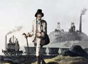
Following the land enclosures of the 1730s, the village of Torrance began to develop. The name is believed to come from the Gaelic ‘An Toran’. Principal industries in the area were limestone, coal and ironstone mining, linen weaving and farming. As local roads began to improve and the Forth & Clyde Canal was opened, a wharf, constructed at Hungryside facilitated the transportation of farm produce and minerals to local markets nearby.
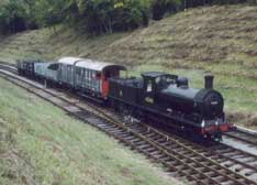
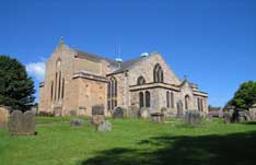
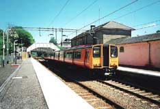
In the 1869, a new village hall was erected at a cost of one hundred and ninety seven pounds and seven pence, it became known locally as “The Free Kirk Box” as it had no porch or vestry although these were added later. It became the Torrance Parish Church in 1929 following the union of the United Free Church of Scotland and the Church of Scotland. Widely used by the local community, it is one of the oldest buildings in Torrance. In 1879, a station was opened at Torrance by the Kelvin Valley Railway Company which linked the village to the national rail network. The line closed in 1951.
Milton of Campsie
Milton-of-Campsie has a population of approximately 4,000. Its name may be a corruption of ‘Mill Town’ as there were three corn and two lint mills operating in the area during the 18th century, the latter producing flax for the linen industry.
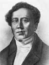
The most significant employers at this time were the Kincaid and Lennox families. In the centre of Milton is a plaque commemorating one of the world’s first aeronauts, Vincenzo Lunardi. The intrepid balloonist landed there on 5th December 1785 and attracted much attention from the local population.
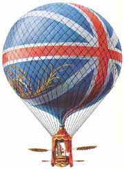 He was a flamboyant young Italian whose balloon ascents in Scotland were very successful and totally eclipsed those of Scotland’s first aeronaut, James Tytler. Lunardi was a popular hero of the period who made a number of flights in Scotland and adverts in the Glasgow Mercury in early November 1785 announced that he intended to “gratify the curiosity of the public of Glasgow, by ascending in his Grand Air Balloon from a conspicuous place in the city”.
On the 23rd November 1785, an immense crowd gathered in St Andrew’s Square to witness the flight. The weather was fine and Lunardi “ascended into the atmosphere with majestic grandeur, to the astonishment and admiration of the spectators”. He landed near Hawick having travelled a distance of 110 miles in two hours.
In 1786, a calico printing works was opened at Kincaid with the emphasis on cotton and not linen as hitherto. The factory became a major employer of local labour and, as it grew, so too did the village of Milton. Textile printing was to dominate the local economy until the early years of the 20th century.
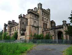
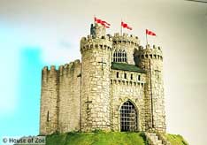
 In 1837, John Lennox Kincaid Lennox inherited Woodhead, not far from the Lennox estate. He combined the two and had a massive property built for himself and his family. This became known as Lennox Castle and took four years to build. The property still stands to this day but was latterly used as a hospital for the mentally ill. It was formally opened by the Lord Provost of Lennoxtown in 1936 with what must now be regarded as a politically incorrect title – ‘Lennox Castle Certified Institution for Mental Defectives’. The conversion cost was £1.25 million and provided 1,200 beds. The building has a Category A listing but is desperately in need of repair.
During the railway age in the first half of the 19th century, a station was built at Milton by the Edinburgh & Glasgow Railway in 1848. This proved to be an asset to the village enhancing its prosperity. Sadly, competition from an increasingly competitive road transport industry and declining railway profits led to the closure of the line in 1951.
Among several local benefactors worthy of mention is Alexander McNab (1819-1897) who once owned the calico printing works. His many charitable acts include the supplying of gas and running water to Milton village and the funding of a public hall in 1887.
Milngavie
Milngavie is a town with a population of around 13,000. Its name is thought to be of gaelic origin meaning either “the mill of David” or “a windy knoll”. Milngavie is believed to have been established in the 15th century.
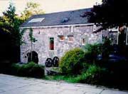 The village was built on the banks of the River Allander where a mill for the grinding of corn was central to the local economy. Gavin’s Mill, as it is popularly known, was restored in the 1960s and remains a popular tourist attraction to the present day.
In 1793, Milngavie’s population was estimated at 200, most of whom were employed in bleaching, printing, cotton spinning, papermaking, dyeing, the pencilling of cloth and the distilling of whisky. The Tambowie Whisky Distillery provided work for a lucky few. Established in 1780, the plant was producing 48,000 gallons of malt whisky by the mid-1880s but was destroyed by fire in 1920.
 Milngavie was once surrounded by a number of private estates – some dating back to the 13th century. One of these, Dougalston was originally owned by the Graham family. Sir John de Graham was a friend and supporter of William Wallace and died fighting at his side at the Battle of Falkirk in 1298. In 1767, Dougalston was purchased by Tobacco Lord, John Glassford, one of the richest men in Scotland at the time. He owned six bleaching fields in and around Milngavie and employed local labour to work them. Two listed buildings built during Glassford’s tenure at Dougalston have survived – The Factor’s House (Category A listed and now a private residence) and the Dovecot (Category B listed and located close to the Esporta golf course). Also listed (but having no Glassford connection) is Corbie Ha’ in Milngavie. This old farm house was occupied until 1966 and is thought to date back to the late 18th century. It has a Category B listing.
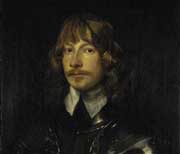 Milngavie has also strong connections with nearby Mugdock Castle once stood on Clan Graham land and was the property of James Graham, 1st Marquis of Montrose and Captain General of Scotland. Born in 1612, he supported King Charles I during the English Civil War and paid for it with his life. Having been captured by the Covenanters in the aftermath of the Battle of Carbisdale in 1650, he was taken to Edinburgh and executed under appalling circumstances maintaining loyalty to his monarch till the end.
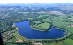 During the mid-19th century, Glasgow’s city councillors were increasingly concerned about the frequent cholera epidemics occurring in the city largely due to the impurity of the city’s water supply. This prompted a scheme of massive investment culminating in the opening of the Loch Katrine–Mugdock waterworks in 1859 by Queen Victoria and the construction of a separate system supplying water from Loch Katrine to Craigmaddie reservoir in 1886.
 One of the scheme’s most vociferous supporters was Glasgow Baillie Archibald MacLellan, who had donated previously large sums of money for the restoration of Glasgow Cathedral which had fallen into an advanced state of decay. MacLellan resided at Mugdock Castle for many years and died there deeply in debt in 1854 and was never to see the Loch Katrine scheme completed. Today, the reservoirs and their beautiful surroundings attract many walkers and naturalists.
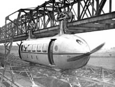 Visitors to Milngavie between the years 1930-55 would have encountered a strange sight – The Bennie Railplane. This experimental form of transport was designed essentially to carry passengers leaving freight to be conveyed by the railways. George Bennie, its inventor, believed that his railplane could run suspended from an overhead rail above the existing railway tracks at speeds of up to 120mph. A 400 foot test track was assembled at Auchenhowie designed to carry a cigar-shaped rail car fabricated from an aluminium alloy and driven by propellers at either end. Sadly, little interest was shown in Bennie’s invention and it lay rusting at Milngavie until broken up in the mid 1950s.
Bearsden
Bearsden has a population of approximately 29,000. In the past, the area which would eventually become known as Bearsden was variously called Kirktoune, New Kirk or New Kilpatrick.
 It was only a small hamlet located at the heart of which was the Parish Church of New Kilpatrick and had existed since 1649. By the end of the 18th century, it had grown somewhat and boasted four oat mills, two barley mills, a snuff mill and several smithies, one of which was located at Canniesburn.
 In 1863, the Glasgow & Milngavie Junction Railway was opened and the company built a station in the area naming it Bearsden, however the origin of the name remains unclear. It proved an attraction to Glasgow’s business community as it offered a quality environment in which to live yet was only a few miles from the City bustle.
During the twentieth century Bearsden expanded and developed. In addition to large villas, other private house types were laid out. One significant early twentieth century development was the creation of Westerton Garden Suburb in 1912, the first project of its kind in Scotland. In 1958, Bearsden was given Burgh status and became part of East Dunbartonshire Council in 1996.
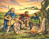 Despite this comparatively recent history, Bearsden and its environs were occupied by our ancestors for thousands of years. Finds of stone axeheads, arrowheads and cup and ring markings carved into stone suggest that the area was peopled in Neolithic times (4,000 – 2,500 BC). Later settlers included the iron-using Celts and by the 1st century AD, a Celtic tribe called the Damnonii (right) had occupied most of the territory today known as Strathclyde. While historic evidence of these peoples is scant, being confined to a small number of artifacts and burials, the same cannot be said for the Romans who occupied much of Southern Scotland during the 2nd century AD.
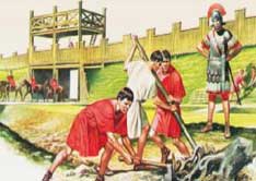
 It was Emperor Antoninus Pius who ordered the building of the Antonine Wall on the Forth and Clyde isthmus in AD 140s. It measured 60 km with forts built at approximately 3.5 km along its length one of which was sited at Bearsden. Sections of the base of the Wall have been exposed and can be seen at New Kilpatrick Cemetery.
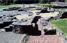
The Bearsden fort was excavated in 1973. As built, it contained barrack blocks, stables, storehouses, granaries and a bath house. The bath house, is the most substantial of Bearsden’s Roman remains and is located near the town centre in the appropriately named Roman Road.
Sited just over a mile from the bath house is the Roman fort at Castle Hill and is similar in size to the Bearsden fort. Three inscribed stones have been found in and around the site all of which are housed in the University of Glasgow’s Hunterian Museum. These praise the Emperor Antoninus Pius and state the lengths of the Antonine Wall completed by each legion.
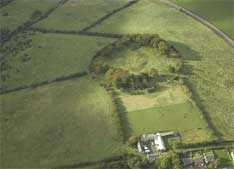 An altar honouring the ‘Goddesses of the Parade Ground’ was discovered in the 19th century and can be seen in the image below. The fort itself is surrounded by a circle of trees but aerial photographs clearly show the disposition of the site. Located 400 feet above sea-level, it has one of the finest prospects of any fort-site on the Wall. Besides the view north to the hills and eastwards, there is a wide outlook westwards and south-westwards over the estuary of the Clyde. The Antonine Wall was recently awarded World Heritage status.
Kirkintilloch
Kirkintilloch is a town with a population of over 20,000. It’s history dates back to Roman times when the legions of the Emperor Antoninus Pius constructed a fort there in 142 AD.
 This formed part of the Antonine Wall which was recently awarded World Heritage status. Little is known of the area’s history during the Dark Ages although it was during this period that the settlement was known as ‘Caerpentalloch’ which translates as ‘The Fort at the Head of the Ridge’.
 In the 12th century, the powerful Comyn family built a castle in what is now Peel Park and a parish church. In 1211, they petitioned King William the Lion, King of Scots, to make the town a Barony Burgh. This was duly granted which meant that the town could hold a weekly market. This is thought to have been located at the foot of Peel Brae which, along with High Street and Cowgate, was one of the three medieval thoroughfares in the town. It established the foundations for the growth of what was to become a thriving town.
The castle was of some importance during the Wars of Independence when an English garrison was stationed there. Soldiers from the castle were despatched to arrest William Wallace at Robroyston and to escort him to Dumbarton Castle. The castle, when excavated in 1899, revealed walls almost 4 metres thick surrounded by a dry moat, the remains of which can be found in Kirkintilloch’s Peel Park.
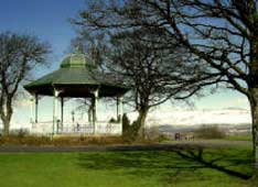 The high ground occupied by Peel Park is recognised as a place of some historical significance as the Antonine Wall passed through it. Over the years, many artifacts have been unearthed indicating that the site was once a Roman fort. The park also features an Edwardian bandstand and fountain both fashioned in Kirkintilloch by the Lion Foundry, famous for its decorative ironwork dating from 1905. Lion Foundry closed in 1984.
Peel Park has recently been restored to its former glory thanks to a grant from the Heritage Lottery Fund. The bandstand has been refurbished and aspects of Roman and Mediaeval history are interpreted via a history trail.
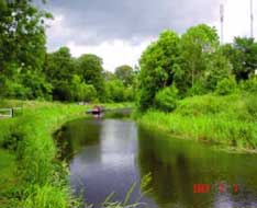
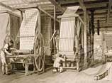
 The Forth & Clyde Canal, engineered by John Smeaton, was begun in 1768 and, after delays due to funding problems, was eventually completed in 1790. This greatly improved transport links with the fledgling town but it was the arrival of the railways which had the greatest impact. In 1826, the pioneer Monkland & Kirkintilloch Railway was opened which led to the establishing of a number of local industries including cotton, weaving, iron founding and boatbuilding. With reference to the latter, the firm of J Hay & Sons (later J & J Hay Ltd), whose yard was adjacent to the Townhead Bridge) became famous for the construction of canal craft and the ubiquitous puffers (see image) which provided inspiration for Neil Munro’s ‘Para Handy’ tales and a lifeline those living in the Inner and Outer Hebrides. Hay’s also produced the canal pleasure steamers ‘Gypsy Queen’, ‘Fairy Queen’ and ‘May Queen’ which were very popular with day-trippers. Hay’s yard was demolished in 1954.
Among the notable buildings in Kirkintilloch are the Auld Kirk, built in 1644. It now serves as the town’s museum. Adjacent to it is the Barony Chambers, built in 1814-15. In the past, it served as the Kirkintilloch Town Hall, Council Chambers, Court House, a school and even the local jail. Today, it houses East Dunbartonshire Council’s Museum Service. 2011 marked the 800th anniversary of the town’s foundation.
Bishopbriggs
Bishopbriggs has a population of over 23,000. The area was once part of the historic parish of Cadder created from lands granted by King William the Lion to Jocelyn, Bishop of Glasgow in 1180.
 It was first documented in the Cadder Parish records in 1655 and, by the mid-18th century, its population was only 11. The area suffered badly during the Lowland Clearances and this was attributed to new agricultural methods which combined small farms and swept away independent tenants. Matters improved with the completion of the Forth and Clyde Canal in 1790 which attracted the ironstone and coalmining industries.
 It was the Falkirk-based Carron Company which became the area’s main employer. It built mining villages at Jellyhill and Mavis Valley to house its workforce while the Forth and Clyde Canal provided a direct transport link to the Company’s centre of operations. Even so, the population of Bishopbriggs was a mere 175 in 1836 and employment suffered further with the opening of the Edinburgh & Glasgow Railway which competed with the Forth and Clyde Canal for the transporting of coal to the Carron Works.
It was the quarrying industry which helped spur the economic recovery of the area. From the mid-19th century, Glasgow’s City fathers initiated a series of municipal building projects including the construction of a new main building for the recently re-sited Glasgow University. The material used was blonde-coloured Bishopbriggs sandstone which remained much in demand in Victorian and Edwardian Glasgow until the early years of the 20th century.
Bishopbriggs suffered an economic decline in the early decades of the 20th century but matters slowly improved from the late 1920s. Firms identified with the area from this time included the Scottish Wire Rope Company (Crowhill), Trebor Bassett (Huntershill) and Blackie & Sons (Cadder).

 During World War II, the town was bombed by the German Luftwaffe on 7th April 1941 – three weeks after the Clydebank Blitz. Twelve civilians were killed.
Among those notable Scots who have made an indelible mark on their country’s history, Thomas Muir of Huntershill (1765-1799) ranks among the greatest. He made a significant contribution to political reform and to this day is regarded as an outstanding campaigner and champion of the rights of the citizen.
Lennoxtown
Lennoxtown, founded in 1786, has a population of just under 4,000. Until the 1790s, the village was known as Newtown-of-Campsie but close ties to the Lennox family, who owned the local corn mill inevitably meant that the village would become known as Lennox Town and subsequently Lennoxtown.
 In the late 1780s a calico printing works founded by Lindsay, Smith & Company was established and before long, the area began to prosper. The demand for labour led to an influx of families to the district and created the need for new housing. This in turn attracted builders and shopkeepers eager to cash in on Lennoxtown’s new-found prosperity.
 In 1805, the calico works was purchased by Robert Dalglish, Falconer & Company and its operations expanded. By this time, other industries had set up production in the area or were on the verge of doing so. These included Kincaid Field’s bleaching and cotton printing, J & W Somerville’s Kali Nail Works and Charles MacIntosh’s Alum Works. Others would follow, as a consequence of which, the population of Lennoxtown and its environs continued to grow.
Domestic industry also flourished so that by 1810, there were around 400 weavers in the district. Those who were skilled in this trade were fortunate for in 1829, the calico works closed permanently rendering all who worked there unemployed. A century later, in June 1939, C W Somerville and J B Webster purchased the land owned by Calico Printers Association, brought in 100 skilled workers and opened for business in 1941. However, the company’s main markets were in India and the Far East and, when these gained their independence, production plummeted.
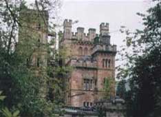 The company was rescued from bankruptcy when it was acquired by Coltness Industries Ltd in 1956 but it was not to last. The company ceasing trading in 1992. Lennox Castle, built to a commission from John Lennox in 1837. It was sold for what was then the massive sum of £25,000 in 1927.
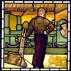
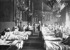
The property was purchased by Glasgow Corporation in 1936 and became a hospital for the mentally ill. During World War II, it was requisitioned under the Emergency Hospital Scheme to accommodate war wounded (right). The hospital closed in 2002 but was badly damaged by fire in 2008.